Langtang National Park Nepal: Complete Guide (Location, Map, Wildlife, Permit, Travel Info)
Langtang National Park is Nepal's first Himalayan national park. It sits north of Kathmandu, close to the Tibetan border, and protects one of the most ecologically and culturally rich mountain landscapes in Asia. The park is home to the red panda, snow leopard, over 370 bird species, and ancient Tamang communities that have lived in these valleys for centuries.
For anyone wanting to understand the Langtang region, this guide covers everything: what the park is, where it sits, what lives inside it, how to get there, what permits you need, and what the park faces today.
Overview of Langtang National Park
Langtang National Park was established in 1976. It holds the distinction of being Nepal's first national park in the Himalayan zone and the fourth protected area in the country overall. Royal approval for the park's creation came as early as 1970, and it was formally gazetted six years later.
The park covers a total area of 1,710 square kilometers. In 1998, a buffer zone of 420 square kilometers was added, expanding the protected landscape to roughly 2,130 square kilometers. The park contains 26 village communities and is home to approximately 4,500 people, most of them Tamang and Kerung in origin.
The altitude inside the park spans from around 1,000 meters in the lowest subtropical sections to 7,245 meters at the summit of Langtang Lirung, the park's highest peak. This vertical range of over 6,200 meters creates an extraordinary layering of ecosystems — from warm subtropical forest floors to permanent glaciers and alpine ice at the top.
The park is famous for several things. It is the closest Himalayan national park to Kathmandu, reachable by road. It protects flagship endangered species like the red panda and snow leopard. It holds Gosaikunda, a sacred lake at 4,300 meters revered by both Hindus and Buddhists. And it preserves the Tamang cultural landscape, including ancient monasteries, traditional stone villages, and trade routes that once connected Nepal to Tibet.
Langtang National Park is part of the Sacred Himalayan Landscape, a trans-boundary conservation corridor that extends from Nepal eastward through West Bengal and Sikkim in India into the Torsa Strict Nature Reserve in Bhutan. In the north, the park connects with the Qomolangma National Nature Preserve in the Tibet Autonomous Region.
Where is Langtang National Park Located
Langtang National Park is located in north-central Nepal, primarily within Rasuwa District. It also extends into parts of Nuwakot and Sindhupalchok Districts. The park lies in the Bagmati Province.
The nearest major city is Kathmandu. The park begins approximately 30 to 32 kilometers north of the Kathmandu Valley and stretches northward to the Tibetan border.
To the north, the park shares a boundary with the Tibet Autonomous Region of China. It directly connects with the Qomolangma National Nature Preserve across this border. To the south lies the Shivapuri Nagarjun National Park. To the northwest sits the Manaslu Conservation Area, and to the east, Sagarmatha National Park.
The eastern boundary of the park follows the Bhote Koshi River. The western boundary follows the Trishuli River. These two rivers, fed by glacial meltwater from the Himalayan peaks, define the geographic edges of the park on either side.
On a map, Langtang National Park occupies a long corridor running roughly east to west along the central Himalayan range. The Langtang Valley runs through the middle of this corridor, serving as the main access route into the heart of the park. The valley is oriented west to east, with the main Himalayan range forming a wall along the northern side and the Ganesh Himal range rising to the south.
Langtang National Park Map and Geography
The geography of Langtang National Park is defined by extreme vertical change. Within a relatively short horizontal distance, the terrain moves from forested river gorges through subalpine meadows to glaciated Himalayan summits.
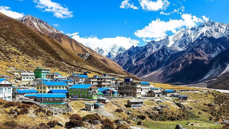
The Langtang Valley is the defining geographic feature of the park. It begins near Syabrubesi at approximately 1,500 meters, where a road from Kathmandu ends. From there, it rises sharply through a narrow forested gorge before widening into open terrain at higher elevations. The valley broadens considerably near Kyanjin Gompa at 3,850 meters. From there it continues eastward toward the glaciers near the Tibetan border.
The valley is flanked by towering peaks on both sides. Langtang Lirung at 7,245 meters dominates the northern wall. Gangchenpo at 6,388 meters and Naya Kangri at 5,846 meters rise to the south. At the eastern end of the valley, Dorje Lakpa at 6,988 meters closes off the view toward Tibet.
The park contains over 70 glaciers of varying sizes. These glaciers feed the Langtang River, which flows westward through the valley and eventually joins the Bhote Kosi River near the western edge of the park.
Gosaikunda is one of the most important features within the park. It is a high-altitude freshwater lake sitting at 4,300 to 4,380 meters above sea level. The lake is the largest in a network of nearby alpine lakes that together cover approximately 1,030 hectares. In the warmer months when the ice melts, Gosaikunda feeds into the Trishuli River. The lake holds deep religious significance for both Hindus and Buddhists and draws pilgrims every year.
The Langtang and Ganesh Himal mountain ranges both run through the park. The Dorje Lakpa range bisects the park from west to east and southeast. The total count of named peaks within the park stands at 68, of which Langtang Lirung at 7,245 meters is the highest and most prominent.
Area and Altitude of Langtang National Park
The core park area is 1,710 square kilometers. The buffer zone of 420 square kilometers was added in 1998. Together, the total protected landscape covers around 2,130 square kilometers.
The altitude range spans over 6,200 meters of vertical relief, from approximately 1,000 meters to 7,245 meters. This exceptional vertical range creates five distinct ecological zones stacked on top of each other within the park boundaries.
Subtropical zone (below 1,000 m) Found at the lowest reaches of the park's southern edges. Dominated by sal forest (Shorea robusta) and tropical tree species. Warm, humid, and dense.
Temperate zone (1,000 m to 2,500 m) The widest and most diverse zone. Dominated by chirpine (Pinus roxburghii), Nepalese alder, and the lower forms of rhododendron. This is where the majority of the park's forest biodiversity concentrates. Bamboo is common in this zone, making it the primary habitat for the red panda.
Subalpine zone (2,500 m to 3,500 m) Characterized by oak, silver fir, hemlock, larch, and dense rhododendron forests. The upper part of this zone includes birch and juniper. Multiple species of rhododendron bloom here in spring, including Rhododendron barbatum and Rhododendron arboreum. This zone is the transition habitat between dense forest and open alpine terrain.
Alpine zone (3,500 m to 5,000 m) Open meadows, dwarf shrubs, and scattered juniper. Alpine grasslands support Himalayan tahr, musk deer, and occasional snow leopard movement. The treeline falls within this zone.
Nival zone (above 5,000 m) Permanent snow, ice, glaciers, and bare rock. Very little vegetation. The highest peaks, including Langtang Lirung, fall within this zone.
The park exhibits 14 distinct vegetation types across 18 ecosystem types, making it one of the most ecologically complex parks in Nepal.
Kathmandu to Langtang National Park Distance and Access
The distance from Kathmandu to Syabrubesi, the main entry point for Langtang National Park, is approximately 120 to 140 kilometers by road. The drive takes 6 to 8 hours depending on road conditions and the season.
The most common route goes from Kathmandu to Trishuli Bazaar and then north to Dhunche (the district headquarters of Rasuwa District at 1,950 meters), and onward to Syabrubesi at approximately 1,462 meters. Dhunche is also an entry checkpoint where trekkers can obtain their national park permit if they have not already done so in Kathmandu.
The road is paved in sections but becomes rough and partially unpaved beyond Trishuli. The stretch from Dhunche to Syabrubesi involves narrow mountain roads with sharp bends and steep drops. Road conditions worsen significantly during the monsoon season from June to September due to landslides and road washouts.
Private jeeps and local buses operate between Kathmandu and Syabrubesi. Bus services run from Machhapokhari in Kathmandu. Private jeep hire is the faster and more comfortable option, especially for groups.
There is no airport serving the Langtang region. All access is by road. This makes Langtang distinct from the Everest and Annapurna regions, where flight access exists. It also means travelers should plan extra time for the journey and build in contingency for road delays.
Langtang National Park Permits
All visitors entering Langtang National Park must carry two documents: the Langtang National Park Entry Permit and a TIMS card (Trekkers Information Management System card).
The TIMS card records trekker information and is used for safety tracking. It is essential for search and rescue coordination in emergencies. The system allows park authorities to monitor who is inside the park at any time, which was especially valued after the 2015 earthquake response.
Where to get permits:
Nepal Tourism Board (NTB) office at Bhrikutimandap, Kathmandu
Trekking Agencies' Association of Nepal (TAAN) office, Kathmandu
At the entry checkpoints in Dhunche or Syabrubesi
Trekking agencies in Kathmandu typically handle permit collection on behalf of clients.
Important note from 2025: As of February 17, 2025, all trekkers in Langtang National Park are required to be accompanied by a licensed trekking guide. This rule applies to all nationalities, including Nepali nationals, and to both individual travelers and groups. The policy is jointly enforced by the park authorities and TAAN.
Children under 10 years of age do not require a national park entry permit.
Flora and Fauna of Langtang National Park
Langtang National Park holds 1,043 species of vascular plants, 15 of which are endemic. It supports 46 species of mammals, 373 species of birds (official NTB figure), 70 species of butterflies, 4 species of reptiles, and 40 species of fish.
Animals Found in Langtang National Park
The park's wide altitude range supports an unusually varied mammal community. Species span from subtropical forest mammals at the lowest elevations to cold-adapted high-altitude specialists near the glaciers.
Red panda (Ailurus fulgens): Found in the temperate and lower subalpine zones, primarily between 2,000 and 2,800 meters. It depends heavily on bamboo as its main food source and prefers dense mixed forests near river drainages. It is shy, largely solitary, and most active at dawn and dusk. The IUCN classifies it as Endangered. Langtang National Park is one of the most important protected habitats for the red panda in Nepal.
Snow leopard (Panthera uncia): Occupies the alpine and subalpine zones above 3,500 meters. Extremely rare and difficult to see. It hunts Himalayan tahr and musk deer and is mostly active at night. The IUCN lists it as Vulnerable. Camera trap surveys have confirmed its presence within the park, though population estimates are low.
Himalayan black bear (Ursus thibetanus): Found in the forest zones between 1,500 and 3,500 meters. It is omnivorous and forages in forest edges and near cultivated land at lower elevations. Most active in early morning and evening. It is occasionally spotted in the subalpine transition zone around Kyanjin Ri.
Musk deer (Moschus chrysogaster): Lives in dense forests and alpine shrub zones, typically between 3,000 and 4,000 meters. Shy and mostly crepuscular. Musk deer are poached for the musk gland used in traditional medicine, making them a priority species for park protection efforts.
Himalayan tahr (Hemitragus jemlahicus): A wild mountain ungulate found on steep rocky slopes and open alpine grasslands above the treeline. Often seen grazing in groups at higher elevations. It is a key prey species for the snow leopard.
Other notable mammals: Wild dog (Cuon alpinus), ghoral, serow, Himalayan brown bear, grey langur monkey, rhesus monkey, pika (a small high-altitude mammal), and muntjac (barking deer).
Birds Found in Langtang National Park
The park holds 373 bird species according to the Nepal Tourism Board's official count. Some field sources list higher figures up to 479 species when accounting for migratory and seasonal visitors. The variety is driven by the park's altitude range, which creates multiple distinct bird habitat zones from subtropical forest floor to high alpine cliff.
Himalayan monal (Lophophorus impejanus): Nepal's national bird. The male is one of the most visually striking birds in the Himalayas, with metallic iridescent plumage across every color. Typically seen in the higher forest and alpine zones, especially in the early morning. The IUCN lists it as Least Concern but it faces pressure from hunting.
Crimson-horned pheasant / Satyr tragopan (Tragopan satyra): Found in dense rhododendron and mixed forest between 2,400 and 4,250 meters. Shy and rarely seen despite its bold plumage. Considered a prize sighting among birdwatchers.
Ibisbill (Ibidorhyncha struthersii): A distinctive shorebird found along the stony riverbeds and glacial streams within the park. One of the more unusual species visitors can encounter near the Langtang River.
Snow partridge (Lerwa lerwa): Found at high alpine elevations near and above the snowline. Well-camouflaged against rocky terrain.
Other notable birds: Bar-headed goose, grandala, wallcreeper, Himalayan snowcock, lammergeier (bearded vulture), various species of rosefinch and accentor, and multiple eagle and vulture species.
The park is also an important stop for migratory species during spring and autumn passage, including bar-headed geese that fly across the Himalayas.
Plants Found in Langtang National Park
The 1,043 species of vascular plants in the park include 15 endemic species. The vegetation changes dramatically with altitude, creating visible bands of distinct plant communities as you move through the park.
Rhododendron forests: The most iconic plant community in the park. Multiple species of rhododendron grow in the subalpine zone between 2,500 and 3,500 meters. Key species include Rhododendron barbatum (with distinctive bristly bark), Rhododendron arboreum (the tree rhododendron, producing deep red blooms), and several other species. These forests bloom most vigorously in spring, turning the hillsides crimson, pink, and white from March to May.
Bamboo: Dominant in the temperate zone, particularly in moist forest areas between 1,800 and 2,800 meters. Bamboo forms dense thickets along stream valleys and forest edges. It is the primary food source and habitat for the red panda.
Oak, fir, and larch forests: Silver fir (Abies spectabilis), Nepalese larch (Larix species), and various oak species dominate the mid-elevation forests. These create the dense, cool, green corridors that are characteristic of the trekking trail from Lama Hotel to Langtang Village.
Alpine vegetation: Above the treeline, the landscape transitions to alpine meadows dominated by grasses, dwarf juniper, and scattered low shrubs. Rare Himalayan herbs including jatamansi (spikenard) grow in these high meadows. These plants have traditionally been harvested for medicinal use by local communities.
Subtropical forest: At the lowest elevations, sal trees and tropical species form the lower forest canopy. This zone is the warmest and most humid part of the park.
Red Panda in Langtang National Park
The red panda is the most iconic wildlife species in Langtang National Park and one of the strongest reasons why the park holds conservation significance beyond Nepal's borders.
Habitat in Langtang: Red pandas in the park live primarily in the temperate mixed forest zone between 2,000 and 2,800 meters. They prefer areas where bamboo grows densely under a canopy of fir, oak, and rhododendron trees. The forest between Lama Hotel (2,440 m) and Ghoda Tabela (3,030 m) on the main trekking route passes through prime red panda habitat.
Why Langtang matters for red panda: Langtang National Park sits within the eastern Himalayan region, which holds the largest remaining wild red panda population globally. The park's protected status prevents deforestation of the bamboo-rich temperate forest that red pandas require. Without this protection, the habitat would be vulnerable to firewood collection and agricultural encroachment.
Conservation status: The red panda is listed as Endangered on the IUCN Red List. The global wild population is estimated at fewer than 10,000 mature individuals. Habitat loss, fragmentation, and poaching are the primary threats. Within Nepal, the Department of National Parks and Wildlife Conservation (DNPWC) considers Langtang one of the priority habitats for red panda conservation.
Best chance of sighting: Red pandas are most active at dawn and dusk. They are shy and arboreal, spending most of their time in trees. Moving slowly and quietly along the forested sections of the trail between Lama Hotel and Ghoda Tabela gives the best opportunity for a sighting.
Snow Leopard in Langtang National Park
The snow leopard is the most elusive large predator in the Himalayan region. Its presence in Langtang National Park is confirmed but sightings are extremely rare.
Habitat in Langtang: Snow leopards in the park occupy the alpine and nival zones above 3,500 meters. They move across the rocky terrain above the treeline, hunting prey along ridgelines and cliff edges. The remote areas above Kyanjin Gompa toward the glaciers, and the higher reaches near the Tibetan border, represent the core snow leopard range within the park.
Prey: Their primary prey within the park includes Himalayan tahr and musk deer. They are solitary and mostly nocturnal or crepuscular, which makes visual encounters very uncommon even for park staff.
Conservation status: The snow leopard is listed as Vulnerable on the IUCN Red List. Estimates suggest a global wild population of 4,000 to 6,500 individuals. In Nepal, the total snow leopard population is estimated at 300 to 500 individuals across the Himalayan zone. Camera trap data from Langtang confirms the species is present but camera coverage of the remote upper zones remains limited.
Threats: Retaliatory killing by herders after livestock predation is the primary threat within the park's buffer zone. Climate change is also pushing snow leopard habitat higher in elevation as human settlements and prey base shift upward.
Conservation measures: Anti-poaching patrols, camera trap monitoring, and community-based livestock insurance programs are active in the Langtang region. These programs aim to reduce retaliatory killing by compensating herders for livestock losses caused by snow leopards.
Climate and Weather in Langtang National Park
The climate of Langtang National Park is driven by the southwest monsoon and by the extreme altitude variation across the park. Temperature and precipitation patterns differ significantly between the lower valley sections and the high alpine zones.
Spring (March to May) This is one of the most pleasant periods across the park. Temperatures in lower valleys like Syabrubesi range from 10°C to 22°C during the day. At Kyanjin Gompa (3,850 m), daytime temperatures sit between 5°C and 15°C. Nights remain cold at higher elevations. Rainfall is moderate. Rhododendron forests are in full bloom. Mountain visibility is generally good, though afternoon clouds develop as the season progresses.
Pre-monsoon / Late Spring (May) Conditions become warmer and more humid in the lower zones. Some rainfall begins. Trekking at higher elevations remains viable but afternoon cloud cover increases.
Monsoon (June to August) The southwest monsoon brings heavy, sustained rainfall to most of the park from June through early September. The lower valleys receive significant precipitation. Trails become slippery, leeches are active in forested sections, and river crossings can be difficult or dangerous. At elevations above 4,000 meters, monsoon precipitation often falls as snow. Landslides on the access road from Kathmandu to Syabrubesi are common. Visibility is poor.
Autumn (September to November) The clearest and most stable season. Post-monsoon skies are consistently clear, giving outstanding mountain views. Temperatures at Kyanjin Gompa range from around 0°C to 12°C during the day in October and November. By late November, higher elevations begin to see snowfall. This is the peak trekking season.
Winter (December to February) Cold conditions dominate. Syabrubesi (1,460 m) sees daytime temperatures of 5°C to 12°C. At Kyanjin Gompa (3,850 m), daytime temperatures typically range from -5°C to 5°C, dropping to -10°C to -15°C at night. Heavy snowfall can close passes and the upper trail sections. The park is quieter, trail crowds are absent, but cold preparation is essential.
Best Time to Visit Langtang National Park
Spring (March to May): Highly recommended Spring is one of the two prime seasons for visiting Langtang National Park. The weather is stable, the rhododendron forests bloom across the subalpine zone, and mountain visibility is excellent in the mornings. Birdlife is active during spring migration. This season is especially good for wildlife observation as animals are more active after winter.
Autumn (September to November): Best overall season Autumn is the peak season and the most popular time to visit. The monsoon ends by mid-September, leaving crystal-clear skies and the best mountain views of the year. Trails are dry, temperatures are comfortable, and the landscape is lush and green from the monsoon rains. October and early November offer the finest conditions. This is when wildlife like Himalayan tahr and birds are easiest to observe on the open slopes.
Winter (December to February): For experienced visitors Winter brings cold and snow to the upper sections of the park. Kyanjin Gompa and the trails above it receive significant snow. Tea houses at higher elevations may close or have limited services. The lower trail sections (Syabrubesi to Lama Hotel) remain accessible. For travelers who enjoy solitude, cold-weather conditions, and the chance to see the park with minimal foot traffic, winter has a strong appeal. Red pandas are more commonly spotted in winter as they descend to lower bamboo zones.
Monsoon (June to August): Generally not recommended The monsoon brings heavy rainfall, landslides on the access road, slippery trails, leeches in lower forest sections, and poor visibility. Most trekking activity drops sharply. However, the park is extraordinarily green and lush during the monsoon, and birding can be exceptional. Well-prepared and experienced visitors do visit during this period, but it requires accepting significant challenges.
Accommodation in Langtang National Park
Accommodation inside Langtang National Park follows the standard tea house model common across Nepal's trekking regions. Lodges and tea houses are the primary options along the main trekking routes. There are no large hotels inside the park.
Syabrubesi (1,462 m): The main road-head town and the most common starting point for treks into the park. Syabrubesi has the most developed accommodation in the region, with multiple lodges and tea houses offering private rooms, attached bathrooms, and hot showers. Hot water is available. Facilities here are comparable to basic guesthouses.
Lama Hotel (2,440 m): The first major overnight stop on the main Langtang Valley trail. Several tea houses operate here. Rooms are basic, with shared facilities. Hot water may be available from solar heating or wood boilers.
Langtang Village (3,430 m): Rebuilt after the 2015 earthquake, the village now has a small but functioning cluster of tea houses. Rooms are basic. Hot water and heating are limited at this altitude.
Kyanjin Gompa (3,850 m): The endpoint for most trekkers and the highest settlement in the main valley. Multiple tea houses operate here, though facilities are basic. Hot water is scarce. Heating in rooms is minimal. Acclimatization is important before sleeping here, especially for those arriving quickly from lower elevations. A small cheese factory in the village produces yak cheese, which is a local specialty.
Dhunche (1,950 m): The district headquarters town. Located on the road before Syabrubesi. Has several guesthouses and is a practical overnight option when arriving from Kathmandu late in the day. More developed services compared to trail-side tea houses.
What to expect: Tea houses along the route provide basic meals (dal bhat, noodles, pasta, eggs), hot drinks, and shelter. Prices increase with altitude. Electricity is available in most settlements, with solar and small hydro being common sources. Wi-Fi is unreliable above Lama Hotel. Rooms are small and simple. Sleeping bags are recommended at elevations above 3,000 meters as blankets may be thin.
Things to Do in Langtang National Park
Hiking and trekking: The most common activity. Multiple routes of varying length and difficulty exist within the park. Day hikes from Kyanjin Gompa, including the ascent to Tserko Ri (4,984 m) and Kyanjin Ri (4,773 m), offer exceptional views without requiring overnight planning.
Wildlife observation: The forested sections between Syabrubesi and Ghoda Tabela are the best zones for observing red panda, langur monkey, and various forest birds. The open alpine areas above Kyanjin Gompa offer chances of spotting Himalayan tahr, musk deer, and occasionally snow leopard tracks.
Birdwatching: The park is one of the best birdwatching areas in central Nepal. Spring migration brings many species through the valley. The forest zones between Lama Hotel and Langtang Village, and the high alpine zones above Kyanjin Gompa, host the greatest bird diversity.
Cultural exploration: The Tamang villages along the route, particularly Langtang Village and the monastery complex at Kyanjin Gompa, offer insight into the Tibetan-influenced culture of the region. Prayer flags, mani walls, chortens, and gompas are present throughout the route. The monastery at Kyanjin Gompa welcomes visitors and is one of the oldest in the region.
Photography: The park offers exceptional landscape photography opportunities year-round. Spring provides rhododendron blooms and clear mornings. Autumn gives the clearest mountain backdrops. Wildlife photography requires patience and early starts. The valley between Langtang Village and Kyanjin Gompa offers some of the finest mountain vistas in Nepal.
Yak cheese tasting: The cheese factory at Kyanjin Gompa produces hard yak cheese that has been made in the valley for generations. Visitors can taste and purchase cheese directly from the factory.
Trekking Routes in Langtang National Park
Three main trekking routes operate within Langtang National Park. Each offers a distinct experience.
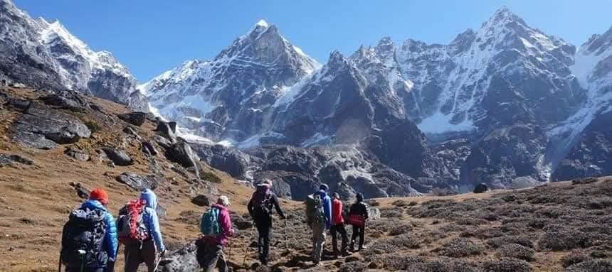
Langtang Valley Trek The most popular route in the park. It follows the Langtang River from Syabrubesi through Lama Hotel, Ghoda Tabela, and Langtang Village up to Kyanjin Gompa. The route offers a gradual ascent through every ecological zone the park contains. Typical duration is 7 to 10 days round trip. For a full breakdown of the route, trail conditions, and itinerary, see the Langtang Valley Trek guide.
Gosaikunda Trek This route ascends from the park's western entry points toward the sacred Gosaikunda lake at 4,300 meters. The trail passes through Dhunche, Sing Gompa, and Laurebina Yak before reaching the lake. It is deeply significant for Hindu and Buddhist pilgrims and is especially busy during the Janai Purnima festival in August. Duration is typically 6 to 8 days. The Gosaikunda route can be combined with the Langtang Valley and Helambu treks via the Laurebina Pass.
Helambu Trek A lower altitude trek in the southern section of the park's buffer zone, passing through Sherpa villages of the Helambu Valley. It is the easiest of the three main routes and is ideal for visitors with limited time or those seeking a gentler introduction to trekking in Nepal. Duration is typically 5 to 7 days.
Impact of the 2015 Earthquake
On April 25, 2015, a magnitude 7.8 earthquake struck Nepal with its epicenter near Barpak in Gorkha District. Langtang Valley, located approximately 86 kilometers from the epicenter, was among the most severely affected areas in the country.
The earthquake triggered a massive glacial avalanche from the slopes of Langtang Lirung. The avalanche combined with an air blast of enormous force, sweeping through the narrow valley at high speed. Langtang Village, sitting at 3,430 meters, was nearly completely buried under ice, rock, and debris. At least 215 people were killed in the park area alone, including local residents and foreign trekkers. Prior to the earthquake, the village had around 55 traditional houses and numerous tea houses hosting trekkers.
The destruction extended to trail infrastructure, bridges, and settlements throughout the valley. The earthquake also severely disrupted the livelihoods of the Tamang communities who depended on trekking tourism.
Recovery was slow and difficult. Langtang Village is three days' walk from the nearest road, and construction materials had to be carried by porters, loaded on mules, or flown in by helicopter at significant cost. Foreign volunteers and aid organizations contributed to early reconstruction, though the reach of aid varied between families.
By 2019, much of the trail infrastructure had been restored. Tea houses were rebuilt. The village returned to receiving trekkers. In 2016, the International Astronomical Union paid tribute to the destroyed village by naming a 9.8-kilometer-wide crater on Mars after Langtang.
The 2015 earthquake fundamentally changed safety protocols in the park. TIMS card registration became more strictly enforced. Trekker monitoring improved. Emergency communication systems were upgraded in several trail stations. The earthquake also reinforced the need for trekkers to use experienced licensed guides who understand the terrain, the risks, and the evacuation routes.
Today, Langtang National Park is fully operational for trekking. The trail is well-maintained, the tea houses are rebuilt, and the communities have returned. Visiting the park is also a direct contribution to the ongoing recovery of the local economy.
Conservation and Environmental Challenges
Langtang National Park faces several overlapping conservation challenges that require long-term management.
Climate change and glacial retreat The park's glaciers are retreating at a measurable rate as Himalayan temperatures rise. This affects both the hydrology of the valley and the habitat of cold-adapted species. The snowline is shifting upward, and perennial snowfields that once provided stable moisture to alpine meadows are shrinking. Species that depend on specific temperature ranges, including the red panda and snow leopard, are being pushed into smaller and higher patches of suitable habitat.
Wildlife habitat fragmentation As species shift upward in response to warming, their habitats compress. The red panda's bamboo zone has a ceiling determined by climate and soil conditions. If warming continues at the current rate, the effective red panda habitat within the park could contract significantly over the coming decades. Similarly, the snow leopard's prey base depends on open alpine terrain that may face increased human use and habitat pressure.
Tourism pressure The park receives tens of thousands of visitors each year, most concentrated in the autumn and spring seasons. The Langtang Valley trail, in particular, experiences significant foot traffic. Waste management remains a challenge at popular campsites and tea house settlements. The park has regulations against single-use plastics and requires visitors to carry out waste, but enforcement is uneven.
Firewood dependency Local communities within the park have historically depended on firewood for cooking and heating. While the park has implemented regulations on wood collection, demand from tea houses serving trekkers creates ongoing pressure on the temperate forest zone. Some settlements have shifted partially to solar and gas cooking, reducing this pressure, but the transition is incomplete.
Poaching Musk deer and red panda are the primary targets of poaching in the park. Musk deer are targeted for the musk pod used in traditional medicine, which commands a high black-market price. Red panda skins and cubs are sometimes taken for illegal trade. Anti-poaching patrols within the park have increased, but the remote terrain makes full coverage difficult.
Buffer zone communities The 26 village communities within the park boundaries create an ongoing management challenge. Balancing the rights and livelihoods of these residents with the conservation goals of the park requires constant negotiation. Buffer zone management councils involve local communities in decision-making, but resource use conflicts persist.
Langtang National Park Office and Management
Langtang National Park is managed by the Department of National Parks and Wildlife Conservation (DNPWC), which operates under Nepal's Ministry of Forests and Environment. The DNPWC is responsible for all 12 national parks in Nepal, along with wildlife reserves, conservation areas, and hunting reserves.
The park headquarters is located in Dhunche, the district headquarters of Rasuwa District. Warden staff at the headquarters oversee conservation activities, anti-poaching operations, wildlife monitoring, and community coordination within the park boundaries and buffer zone.
Entry checkpoints are located at Dhunche and Syabrubesi, where permits and TIMS cards are checked. Additional ranger posts exist at intervals along the main trekking routes within the park.
The park is also part of the Sacred Himalayan Landscape, a trans-boundary initiative coordinated with conservation authorities in India, Bhutan, and the Tibet Autonomous Region. This regional framework supports wildlife corridor management, particularly for wide-ranging species like snow leopard.
Community conservation is a formal component of the park's management model. Buffer zone management committees, composed of local community representatives, participate in decisions about resource use, revenue sharing from permit fees, and community development projects funded by park revenues.
The World Wildlife Fund (WWF) and various international conservation organizations have historically supported wildlife surveys, anti-poaching programs, and community livelihood projects within the park's buffer zone.
Conclusion
Langtang National Park is one of Nepal's most important protected areas. It was the first Himalayan national park established in the country, and it remains one of the most ecologically diverse, holding an altitude range of more than 6,200 meters within a single protected zone.
The park protects flagship endangered species including the red panda and snow leopard. It shelters 373 bird species, 1,043 vascular plants, and 26 village communities. It holds Gosaikunda, a sacred lake of deep religious significance. And it preserves the Tamang cultural landscape, one of the strongest surviving expressions of Himalayan Buddhist culture in Nepal.
The park was severely impacted by the 2015 earthquake but has rebuilt. It now faces different long-term challenges: climate change, tourism pressure, and the ongoing balance between conservation and community livelihoods.
For those planning to explore this region, the Langtang Valley Trek offers the most direct and rewarding route through the heart of the park, from the subtropical forests at Syabrubesi all the way to the glaciers and high peaks at Kyanjin Gompa.
Recommended Treks
Dolpa trek
Chisapani Helambu Trek (5 Days)